LLAMA PROSPECT
The Llama Prospect is a developmental play that looks to extend excellent Gilcrease production established by the Llama # 14-1 well up dip to the east into the west half of section thirteen and also into the southeast quarter of section fourteen. The Llama #14-1 well was originally drilled and abandoned by Keener Oil & Gas Co. in 2012. After the base of oil and gas lease expired I developed a prospect around the plugged well. In 2014 I sold the prospect to Southsands Exploration and in 2015 they reentered and completed the well as a great producer.
The Llama Prospect is primarily looking to develop the existing Gilcrease oil and gas production while also hunting for big find in a Wilcox sand oil field.
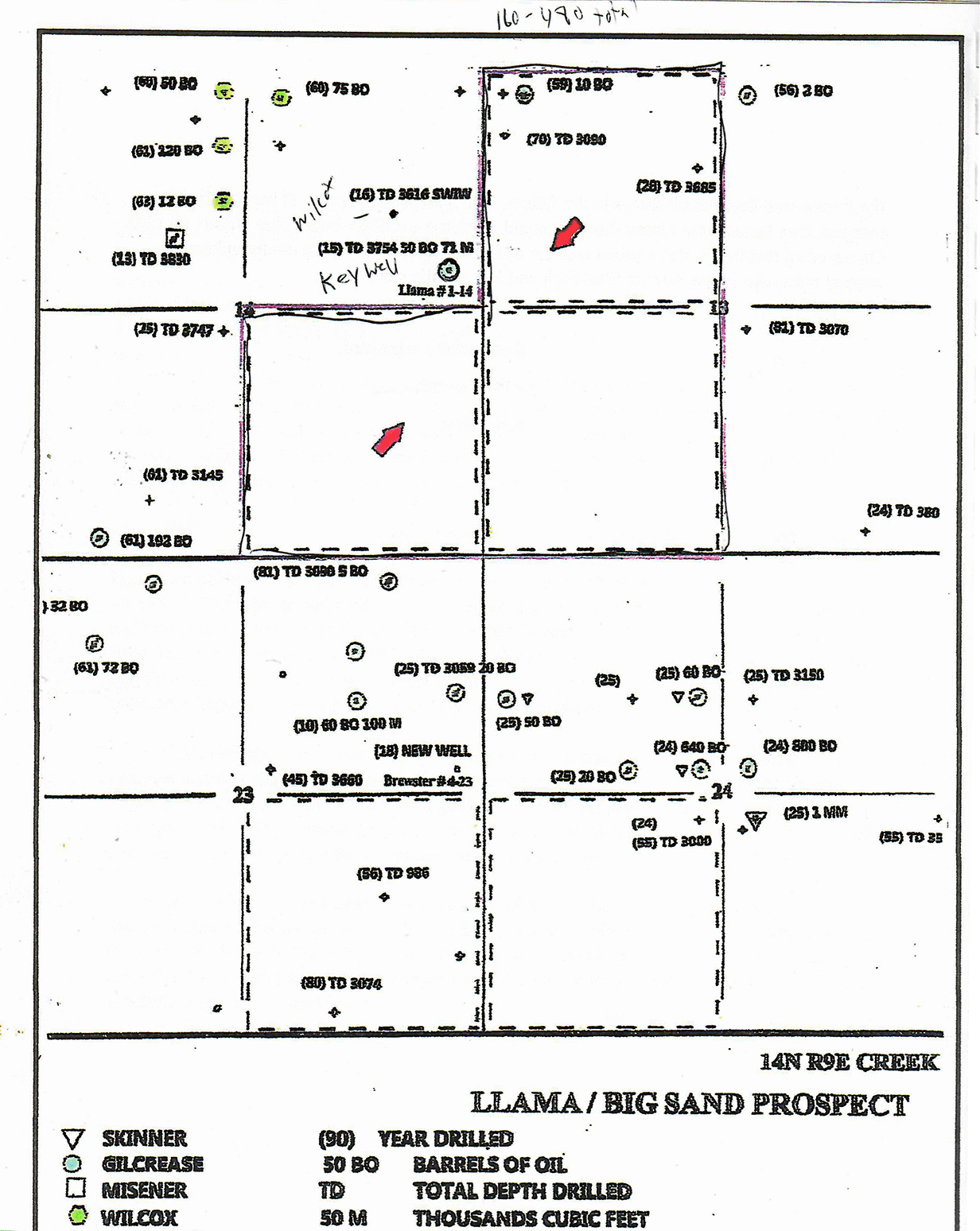
Described as the west half of section thirteen and the south quarter of section fourteen in Township 14 North Range 9 East, Creek County Oklahoma. This prospect contains enough acreage to drill 6 to 12 additional wells as conditions warrant and additional acreage looks to be available if the play turns out to be bigger than we expect.
The Llama #14-1 (SE SE SE Sec14) was drilled February of 2012 by Keener Oil and Gas to a depth of 3754 feet. The Wilcox sand had oil shows but was lower structurally than expected. They did have a good logs and oil and gas shows in the Gilcrease but did not elect to set pipe after the DST was not conclusive.
After Southsands reentered the well and set pipe we competed the Gilcrease sand and performed a modern fracture stimulation. The well had a reported initial production rate of fifty barrels of oil per day with almost one hundred thousand cubic feet of gas. I know this well could easily have produced over two hundred barrels of oil per day, but it was controlled and flowed at only fifty barrels of oil per day to protect the reservoir and to maximize the longevity of the producing formation. It is advantageous to produce the most oil while simultaneously producing the least volume of natural gas that you can. This keeps the formation pressures high and allows you to produce the most oil in the long run. In the early years of oil and gas exploration the gas was vented to get as much oil as fast as possible. This led to many wells and fields being abandoned early because the reservoir drive was wasted and thus they left millions of barrels of oil in the ground.
The Gilcrease sand in this area tends to be an offshore sand bar deposit. The sand bars are trending south to north in stringers paralleling an ancient Pennsylvanian Age shore line. This same offshore sand bar depositional environment can be seen today off the east coast of Florida. The sands tend to be clean with good porosity and permeability. The sand bodies can cover from just a few acres to over 400 acres. Many of these sands are oil and gas filled reservoirs with the production potential dependent on the sands porosity and permeability. Some of these sandbars will have porosities of over twenty two percent while others will be more of a limy sand with porosities from six to ten percent. These Gilcrease sands respond very well to new fracture stimulation techniques and many sands that were overlooked in older wells would be very productive with todays improved fracking.
The way the Llam 1-14 has responded to the fracture treatment and it’s consistent oil and gas production indicates that this well has tapped into a large sand body and that there are additional drill sites that are waiting to be exploited. This prospect is attempting to develop this oil and gas filled sand bar to the east into section thirteen. In this area, regional dip is to the east so the proposed drill site should be up dip from the Llama #14-1 well into a virgin area and will not be affected by the existing production. No wells have ever been drilled in the southwest quarter of section thirteen or in the southeast quarter of section fourteen. This is very unusual for Creek County making this lease then wide open for additional development.
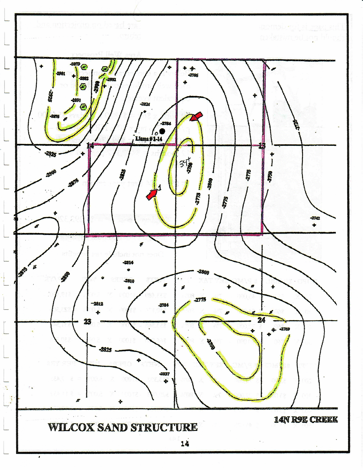
I have compiled all o the Gilcrease sand formation information that is available either through modern electric logs, or old sample descriptions taken while wells were drilled. From this data, I have created a map showing the distribution of the Gilcrease sand during its deposition during the Pennsylvania age. A portion of this thirty-six square mile study is attached as the Gilcrease sand Isopach map. As you can see it appears that a channel extends from the Llama #1-14 to the south in section fourteen and east across section the western half section thirteen. The channel goes from four feet thick in the Llama #14-2 injection well to twenty-two feet thick in the Llama #14-1 well. I expect that the sand will thicken to over thirty feet in the western edge of section thirteen. I also expect the sand bar to extend to the northern and southern edge of section thirteen.
If I calculated the expected reserves on the Gilcrease sandstone reservoir I would come up with numbers ranging above 60,000 barrels of oil per well.
It is perhaps easier and clearer to show an example of the field I hope to develop on these leases. In 1954-55 the Red Bank Gilcrease field was developed in the east half of section ten T16NR8E Creek County. These wells were produced hard with initial production rates of 75 to 619 barrels of oil per day from the thirty foot thick clean offshore bar sand deposit. A map of this field shows a remarkable similarity to the expected Llama field. The Red Bank unit in spite of being poorly managed produced and sold 930,439 barels of oil. This averaged over 77,500 barrels of oil per well. My estimates indicate that the Red bank unit still contains an additional 500,000 barrels of oil that was left behind by the poor production operations on the 1950’s.
If we find as I expect the Llama Gilcrease sand thickens to the east and covers much of the west half of the section then I think we have room for eight good wells that should produce in excess of 60,000 barrels of oil. There are Gilcrease wells in this area that have produced over 110,000 barrels of oil so numbers above 60,000 are reasonable.
Below the Gilcrease sand another favorite target is the Wilcox sandstone. The Ordovician age sand deposit is a blanket sand that covers much of the northeast Oklahoma. It is generally found in structural traps where it has proven to be one of the, if not the most prolific producers. These Wilcox fields can cover just a few acres with one producing well to over three hundred acres and over a dozen producing wells. A small sixty acre Wilcox field can produce over a million barrels of oil.
Originally Keener Oil and Gas drilled the Llama #14-1 to test the Wilcox. Keener is known as a big Wilcox hunter company and has made a fortune from a number of good Wilcox fields just to the west of this prospect in Township 14N Range 8E. They had mapped a structure that was building back from a small field in the northcentral part of section fourteen. South sands drilled the Llama #14-2 disposal well just west of the #14-1 and was down dip in the Wilcox formation. This shows that the structure is building to the east. I have added this data to my Wilcox structure map of T14NR9E and have attached a small part of the map that covers the Llama Prospect. As you can see, we have what appears to be a Wilcox structure across the north half of the south west quarter of section thirteen that extends into the southeast quarter of section thirteen. The S. Aripocia # 1 drilled in 1924 ( SW SE SE 13 T14 N9E) well also reported an oil show in the Wilcox described as brown sand from 3559 to 3570 feet. Brown sand is usually an indicator of oil in the sand. If the Wilcox sand is wet, it is usually described as a white sand as it is below 3570 feet. This would indicate that up to eleven feet of Wilcox sand has oil shows or is in fact an oil and gas reservoir. If the structure is as mapped and filled with oil, then the I can envision four to eight productive Wilcox oil wells across the south half of section thirteen with ultimate production of well over a million barrels of oil from the Llama Prospect.
Wilcox producers tend to produce steadily for decades and that is why they are so highly sought after. WFD Oil has just completed two Wilcox producers in section two T14NR9E. This is just two miles north of the Llama Prospect. Two miles south of the Llama Prospect in section 26 T14NR9E a Wilcox well drilled in 1983 reported an initial production rate of thirteen hundred and ninety-two barrels of oil per day. An example of a small Wilcox field is the East Morgan field. Located in section nine of T12N R11 E this sixty-acre field has produced over 1.2 million barrels of oil to date. From a few barrels to over thirteen hundred barrels a day are all rates of production reported from the Wilcox sand within two miles of the Llama Prospect.
This geologic report and the maps, opinions, interpretations, economic estimates, and analyses which it contains are based upon personal examination and interpretation of various maps, well records, and current and prior geologic studies, the accuracy and reliability of which is not guaranteed. These documents are prepared for the use of knowledgeable and sophisticated persons who realize the risk factors present in any oil and gas venture.
In conclusion, The Llama Prospect has all of the ingredients to be a very successful oil and gas venture. You are moving up dip in offsetting good established Gilcrease production from the Llama #14-1 well. You are in an area that has been under explored with several hundred acres that has never seen a drill bit. Not only is there a lot of room for additional Gilcrease sand production you will be moving up dip from a well that had oil shows in the Wilcox onto a mapped structure. If the structure is as mapped, then beneath the Llama Prospect could be hiding a million-barrel plus Wilcox oil field. On top of all that this is also a prime area for additional reserves form the stratigraphically trapped reservoirs in the Skinner, Red Fork and Bartlesville sandstones.